Industry
Oregon Trail driving from Boise, Idaho: what the westward route requires
A two day Oregon Trail drive from Boise: Three Island Crossing, Snake River ruts, Farewell Bend, Flagstaff Hill, fuel gaps on the high desert and real costs.
What to take away
- Oregon Trail driving from Boise works as a loop. Three Island Crossing lies east of the city, and Baker City lies west.
- Give the drive two days. Glenns Ferry to Baker City runs about 220 miles on I-84 and old US 30.
- Fuel, food and cell service thin out between Mountain Home and Huntington. Fill up in every town you pass.
- The ruts that still read on the ground sit at Three Island Crossing, Farewell Bend and Flagstaff Hill.
- Winter storms and spring mud can close access roads to the interpretive sites.
Start east to Three Island Crossing
Boise sits near the north bank alignment that emigrants used after crossing the Snake.
From downtown, I-84 runs southeast to Glenns Ferry in about an hour and ten minutes. Three Island Crossing State Park marks one of the hardest river crossings on the trail. In good water years, wagons forded to the islands, then to the far bank.
The park's Oregon Trail History and Education Center explains how emigrants read the river. An August reenactment repeats the crossing each year.
Drive back west along the same river corridor. The trail ran this way in reverse, following the north bank toward Fort Boise, near present-day Parma.
Ruts and landmarks on the Idaho leg
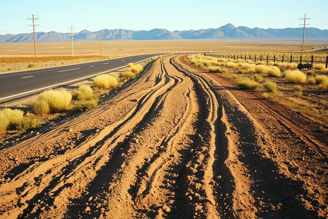
Ruts survive where plowing and heavy grazing never erased them. Several marked sites sit along the Snake River plain.
Idaho's Oregon Trail auto tour route follows the corridor, and markers point to crossings, ruts and emigrant graves.
At Three Island Crossing, short trail traces run down toward the water. Farther west, the National Historic Oregon Trail Interpretive Center sits on Flagstaff Hill outside Baker City, where wagon ruts cut through the sagebrush.
Old alignments move over time, and the NPS Lincoln Highway maps page shows how alignment research works on a historic road.
Read the ground slowly. A rut is often a shallow pair of parallel swales, not a ditch.
West of Farewell Bend, the trail turned away from the Snake and climbed the Burnt River breaks. US 30 and I-84 follow roughly the same line into Baker City today. The water stops are gone, but the shape of the country is not.
Where services run thin
Between Mountain Home and Huntington, towns shrink and cell coverage drops.
A historic highway road trip from Boise does not need a special vehicle, only planning.
Gas exists at Glenns Ferry, Mountain Home, Boise, Caldwell, Ontario and Baker City. Huntington has limited fuel. Do not pass a station on a low tank.
Carry water. High desert heat in July and August is hard on cars and people.
Small-town counters do breakfast better than interstate chains, and the American diner has a long road history worth reading.
If you want a longer diner list, historic diners on US highways collects six stops with drive times.
Example: two days from Boise to Baker City
| Segment | Approx. miles | Services |
|---|---|---|
| Boise to Glenns Ferry | 70 | Fuel and food, limited evening hours |
| Glenns Ferry to Mountain Home | 40 | Full services |
| Mountain Home to Ontario | 100 | Fuel at Boise and Caldwell |
| Ontario to Baker City | 80 | Huntington, limited fuel |
- Day onedrive Boise to Glenns Ferry early, tour the crossing and the visitor center, then sleep in Mountain Home.
- Day tworun west on I-84 and old US 30 to Farewell Bend State Recreation Area, where the trail finally left the Snake River.
- Continue to Baker City and drive out to Flagstaff Hill for the ruts. Return to Boise or stay the night in Baker City.
Every decision on this leg follows the Snake. The river chose the route long before the highway did.
Fees, rules and timing
Idaho State Parks charges a day-use fee at Three Island Crossing. Federal sites near Baker City follow standard public land rules.
If you are starting from the west side, Oregon Trail driving from Portland covers federal land rules, ruts access and Columbia Gorge weather.
Timing matters more than gear. Summer heat and fire season are real. Winter can shut the Flagstaff Hill road.
If you plan a guided version of this drive, timing road trip tour companies in 2027 explains booking windows and shoulder months.
Historic routes change, and the NPS Lincoln Highway history page traces how one old road shifted over time.
Common questions
How long does Oregon Trail driving from Boise take?
Two days covers the crossings, the landmark sites and the high desert stretch without rushing. One long day works if you skip the visitor centers.
Do I need permits or pay fees?
Three Island Crossing charges a state park day-use fee. The sites near Baker City are federal, and rules are posted at each entrance.
Can I drive on the ruts?
No. Ruts are fragile and protected. Park at marked lots and walk in.
When should I go?
Late spring and early fall give cooler driving and open access. Check road and fire conditions before you leave.